Lead Mountain (1 box)
replaced 2007-09-08.
Located near Beddington, Maine, Lead Mountain rises 450 meters above sea level, and makes for a really nice hike. To get there from Bangor, Maine, drive 40 miles east on Rt. 9. Exactly one mile after the intersection with Rt. 193 heading south (which you should not take), you will turn onto a dirt road on the left (North). You will have gone too far if you cross the small bridge over the Narraguagus river 1.2 miles past Rt. 193, though you can see the bridge (really just a flat stretch of pavement with guardrails, but it does cross an obvious river) from where you turn.
Once on the correct nondescript dirt road, you will immediately pass a parking lot on the left and a ranger station on the right. Keep driving, taking a left (West) turn soon after to follow the sign toward Lead Mountain. Ignore the next left turn, as well as the right turn into the gravel pit. After the gravel pit, however, the road condition does deteriorate somewhat. We made it in a VW Beetle, so you can travel it even in a small car, just go slow and avoid the larger rocks. If you feel uncomfortable driving it, you can park near the ranger station and add another 5km (on mostly level ground, though) to your total hike. Keep driving until you reach an obvious parking area, with a gate preventing further driving. From this point, if your car made it, you have a short 2.2km roundtrip hike to the top and back.
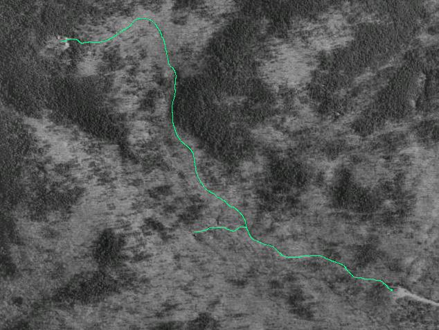
The trail basically only goes one way, with a single turn that immediately reaches a dead-end. Just in case, though, we have provided another of our home-made "trail maps", a 2 meter resolution satellite map to help you. The green line indicates the trail(s), with your car at the lower right, and the peak at the upper left.
From your car, head NW past the gate. Enjoy this first part of the hike, it gets progressively harder. Continue along until you come to a fork. The main path seems to bear left, but that will immediately end at two small buildings, so keep heading uphill and NNE, following a dried stream-bed.
After a few more minutes (depending on how often you need to rest), you will reach a building with various oddities lying about. This makes a good place to rest, with the hardest quarter of the hike remaining. When you can hear over your own heartbeat again, proceed on and the trail will start to bear left as it winds steeply up to the top.
After that last scramble, you will finally enter an open area containing piles of large rocks, two (obvious) radio towers, and a building with a huge solar array on one side. Right after you enter this clear area, turn left to head due south, along the fence and down a short path in the woods. 65 paces later, you will come to another open area providing a bit of a view, and an older and smaller "tower".
From the USGS marker three paces SE from the foot of this "tower", take 16 paces at 250° to a small cluster of pines. Circle around a few feet to the right to get access to their bases, where you will find a small pile of stones. You know what you'll find there. Stamp in.
To get back to your car, go back exactly the way you came. Normally we don't like planting boxes that require you to completely retrace your path, but the way down goes much easier, and you can appreciate how nice of an area you have walked through. Still take care walking though, the rocks can get very slippery.
Please visit the RIBNAG homepage at http://users.tmok.com/~ribnag for more letterboxes planted by us, or just for general information about our group.
This page has received hits.