Things to do with Stone (3 boxes)
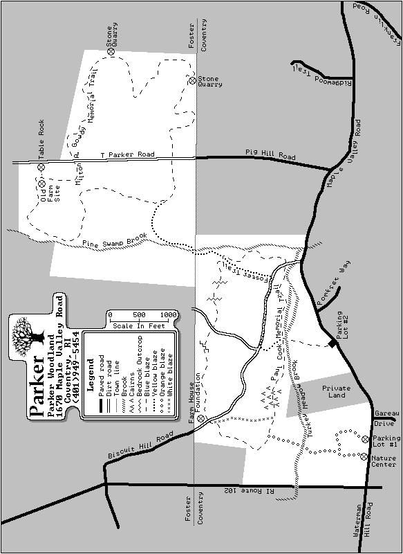
This very easy (but long) Rhode Island hike takes place on the border of Coventry and Foster (roughly half-and-half), at the George B. Parker Woodland. It consists of 10km of hiking along well-blazed trails, with a bit of hilliness but level overall. Bring a snack and plenty of water, and plan to take at least 4 hours (the gate locks at dusk, so...). Although you could bike 99% of this route, and one frequently encounters people with dogs, the Audubon Society does not allow bikes or dogs at refuges they maintain (take that as you will).
From rt.102, approximately 2km north of the intersection with rt. 117, turn east onto Maple Valley Rd. Proceed 1.5km down Maple Valley, then turn left into Parker Woodland's parking lot #1. The trailhead lies just past and to the left of the information board. Pick up a trail map at the information board, or print the map included here (the on-site supply often runs out).
At the first sign (not counting the information board), go right to get onto the orange trail. Proceed a short way until you come to a second sign. Take another right, then down the stairs, to stay on the orange trail. Enjoy the long wooden bridge protecting you from the nasty muck. At a rocky intersection, head right to start on the blue trail. At the intersection with the white trail, turn right to stay on blue.
You will start to see cairns in various states of disrepair scattered about. Shortly thereafter, you will come to a very large cairn right in the middle of the path, with trail marker #6 right next to it. From the west side of this cairn, look at 63°. Before you lay three cairns in a row, and directly behind you a fourth. Go to the third cairn in front of you, approximately 25 paces. From the center of this all-but-erased cairn, look down and due east. Your first box lies hidden by the chunk of quartz.
Go back to the trail, and continue down it until you reach the intersection with yellow, right before a bridge. Take a hard left onto the yellow trail. At the next intersection, relax for a minute on the bench, then head down the forest road (still yellow) on a course of 140°. Watch for yellow to split off to your left, which you want to take (now called "Foster Trail", but still yellow). Soon you'll come to a very large rock, with trails heading in each direction as blue and yellow cross here. Stick to the yellow, at 40°. This will take you to Pine Swamp Brook, which you will walk above, then along, then eventually cross at a bridge. At the bench, bear right, 130°, to begin on a new blue trail (now the "Milton A. Gowdy" trail). After a short way, you will cross Pig Hill Road; go directly across, staying on the blue at 80°.
Continue for rather a long way, until you come to a pair of blue arrow signs on a single tree, at the vertex of the concave indentation in the Foster portion of the trail (look at the trail map and you'll understand). A short while later you will come to an area loaded with scattered boulders. Just after a hard-to-see path on your right (ENE), which leads down to an old foundation, you'll see a waist high boulder just right (ENE) of the trail split neatly in half, with an almost perfectly uniform 10cm gap between the halves. Continue down the path for another 30 paces to come to another waist high boulder directly adjacent to and right of (ESE) the path, this one having a very comfortable place to sit down for a minute. take 10 more paces past this boulder, then look between the twin trees at 100°. Walk to the corner of the large flat rock you see from between the trees. two steps more, and look directly down. The second box lies hidden in a crevise on the north side of this trio of flat rocks. From that point (or just past it) you have a really amazing view of the old quarry spread out below you and to the east, with a foundation to the right, an enormous pile of waste rock in front of you (that "next hill over" actually consists of waste rock from the quarry), and a water-filled pit half visable to the left.
Continue along the blue trail, for another longish stretch. After a while you will cross Pig Hill Road again. Go directly across, heading west. After another short stretch you will see a sign for "Table Rock". Stop in and look, then continue along the trail. When you see the bench, which you saw before, take a hard right to return to the yellow trail. When it returns you to the giant rock where blue and yellow cross, take the blue directly to your right. Proceed along this blue, and when you see the left turn toward "Parking Lot" (#2, incidentally), don't take it, but continue straight on the blue.
Another short stretch will bring you to an old foundation, with trail marker #11. Go down the stairs (remarkably well preserved, but use caution anyway), and notice the tree directly on your left. The final box lies tucked into the eastern wall of the foundation, about half-way up, half-a-meter to the right (south) of the tree nearest the stairs. Please re-hide it well, since this site lies right on the trail.
Continue southwest along the blue trail. Just past the foundation area you will come to an intersection with white. Take the blue trail at 220°. After another stretch of trail, you'll come back to the intersection with the orange trail (the sign says "parking lot #1") on your right. Take it, coming back to the long bridge. Just a short way later, you'll come to another intersection, take the left to stay on the orange trail (again, labeled "parking lot #1). Just one more short stretch, and you end up back at the trailhead. At the sign, you can (somewhat) see the parking lot, so take the left and return to your car.
Please visit the RIBNAG homepage at http://users.tmok.com/~ribnag for more letterboxes planted by us, or just for general information about our group.
This page has received hits.